Imagine a time when the open road wasn't clearly marked by numbered signs, but by painted symbols on trees and boulders, or towering concrete pillars standing sentinel against a vast, untamed landscape. This was the reality of early 20th-century American travel, and at its heart lay an ambitious undertaking known as the Ozark Trail. Far more than just a path, this pioneering highway system laid crucial groundwork for the modern road networks we rely on today, including portions that would eventually become the legendary Route 66. From its humble beginnings as meandering sets of ruts between isolated communities, the Ozark Trail blazed a path towards a more connected nation, leaving behind a fascinating legacy that echoes in the remaining historical markers.
The Dawn of American Roadways: A Vision for Connection
In the nascent years of the 20th century, the automobile was rapidly transforming the way Americans lived, worked, and traveled. However, the infrastructure lagged far behind the innovation. Most roads were little more than dirt tracks, poorly maintained, and completely unmarked. This made inter-community travel a daunting, often impossible, task. It was in this environment that visionary individuals and local associations stepped forward to connect the dots across the burgeoning nation.
One such driving force was William Hope "Coin" Harvey, an Arkansas resort owner and the founder of the Ozark Trail Association. Harvey envisioned a system of marked roadways that would guide travelers and link the widely scattered towns and cities of the American heartland. His foresight predated any significant state or federal involvement in highway maintenance and numbering. These were truly grassroots efforts, fueled by community pride and a desire for progress. The Ozark Trail was born out of this urgent need for connectivity, seeking to transform treacherous ruts into reliable routes, and foster economic growth and social cohesion across vast stretches of the country.
Marking the Way: From Paint to Enduring Pillars
The earliest attempts to mark the Ozark Trail were as rudimentary as they were ingenious. The Ozark Trail Association initially employed a simple yet effective system: a green "OT" enclosed between two green stripes, painted against a white background. This distinctive emblem adorned telephone poles, prominent boulders, barn sides, and virtually any available surface that could hold paint, guiding intrepid motorists along the various branches of the trail.
However, "Coin" Harvey soon recognized the need for more permanent and prominent markers. In 1913, he proposed the erection of "white pillars bearing the inscription 'Ozark Trails.'" His vision gained traction, and by the group's 1918 convention, Harvey galvanized support for concrete obelisks – impressive four-cornered slender shafts topped by pyramids. These monuments were strategically placed at key junctions where the Ozark Trails branched and at intersections with major roadways. The intent was clear: to create unmistakable guideposts that would stand the test of time, a far cry from the temporary painted symbols.
By 1919, the Ozark Trail Association had agreed upon a standard design for these majestic markers. Each obelisk featured a tall, tapered concrete shaft resting on a sturdy square base, often illuminated by five lights. Along two or more of their sides, the names and distances of towns along the Ozark Trail were meticulously painted, serving as an early form of highway signage. Figures like J.E. Swepston of Tulia, who was elected Ozark Trail Association president in 1920, were instrumental in ensuring these markers were placed in their respective regions, solidifying the trail's presence and guiding countless travelers. For a deeper dive into how these early roads were navigated, explore Ozark Trail: Guiding Early America Before Modern Highways.
A Network of Trails: Branches and Bridges to the Future
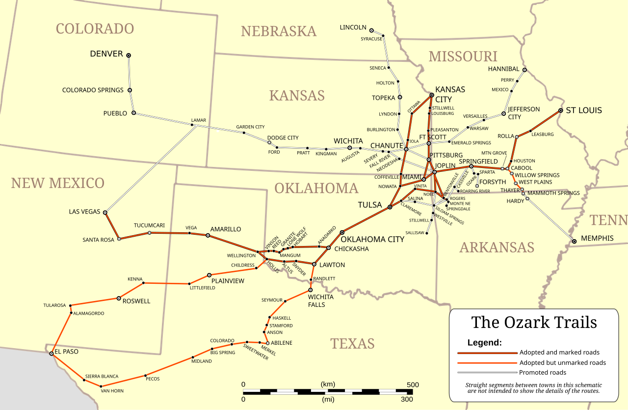
Crucially, the Ozark Trail was never a single, monolithic roadway. Instead, it comprised a sophisticated network of several principal branches, designed to crisscross and connect a significant portion of the American Southwest. Generally, the trail followed a grand line stretching from St. Louis, Missouri, all the way to Santa Fe, New Mexico, forging vital links between growing urban centers and remote communities.
The central Ozark route held particular significance, as key portions of it would later evolve into the iconic Route 66. This central artery passed across Oklahoma through towns like Wellington, laying a direct path for what would become "The Mother Road." Imagine the dirt tracks of the Ozark Trail slowly being paved and absorbed into the legend of Route 66 – a powerful testament to its foundational importance.
Beyond this central branch, a significant southern route was also developed, weaving its way through a series of communities that would otherwise have remained isolated. This southern corridor connected towns such as Childress, Estelline, Tampico, Turkey, Quitaque, Silverton, Tulia, Nazareth, and Dimmitt. These branches weren't just about getting from point A to point B; they were about fostering regional commerce, allowing farmers to get their goods to market, and enabling families to visit relatives across greater distances. The Ozark Trail's foresight in establishing these connections truly helped define the future of American travel, setting the stage for nationwide highway systems.
The Last Sentinels: Discovering Remaining Ozark Trail Obelisks
Despite the grand vision and extensive construction, time and development have taken their toll on the physical markers of the Ozark Trail. While countless obelisks were erected decades ago, today, only a handful are known to survive. According to various online sources, including the Drive The Old Spanish Trail website, a mere seven of these 21-foot tall concrete obelisks are still standing, silent witnesses to a bygone era of road building.
Texas, remarkably, is home to four of these precious historical artifacts. Two of these markers, located in Dimmitt and Wellington, were originally placed in the middle of major intersections. As traffic volumes increased, they were judiciously moved to more traffic-friendly curbside locations, ensuring their preservation while accommodating modern infrastructure. The Wellington marker even underwent a reconstruction to a shorter height. Other survivors include the obelisk in Tampico, a fascinating ghost town nestled between Turkey and Quitaque, which stands proudly in its original location, and another in Tulia, also unmoved from its initial placement.
The Castro County marker, originally positioned at the intersection of U.S. 385 and Texas 86, offers a glimpse into the cost and effort involved in their construction, having been built in the early 1920s for approximately $600. It was later moved to its present location on the courthouse square by pioneer settler Edwin "Goose" Ramey, ensuring its continued visibility and appreciation. This particular marker lists crucial distances in miles from Dimmitt to major regional hubs: Amarillo (63), Lubbock (80), Albuquerque (275), Oklahoma City (325), and Fort Worth (390). These remaining obelisks are not merely old structures; they are tangible links to a pivotal period in American history, offering a rare opportunity to connect with the very routes that helped shape the nation. For those eager to discover these incredible pieces of history, The Last 7 Ozark Trail Obelisks: Discover Historic Road Markers provides invaluable insights.
The Ozark Trail's enduring legacy is a powerful reminder of American ingenuity and perseverance. From guiding early motorists through dusty ruts to influencing the development of the legendary Route 66 and beyond, this pioneering highway system carved out a crucial chapter in our transportation history. The few remaining obelisks stand as stoic monuments to a time when community associations, not government agencies, charted the course for a connected future. As we navigate our modern highways, let us remember the visionaries and the communities who, with paint and concrete, transformed the challenging landscape into a route of progress, forever connecting the nation from ruts to the open road.